Disaster Response Content for Effective Evacuation of Disaster Vulnerable Classes in Case of Disaster
Copyright ⓒ 2018 The Digital Contents Society
This is an Open Access article distributed under the terms of the Creative Commons Attribution Non-CommercialLicense(http://creativecommons.org/licenses/by-nc/3.0/) which permits unrestricted non-commercial use, distribution, and reproduction in any medium, provided the original work is properly cited.

Abstract
Recently, disasters occur frequently in the form of complex disasters that lead to secondary disasters rather than single disasters, but there is a lack of services targeting vulnerable classes. In this paper, we propose the disaster response contents for disaster vulnerable classes with relatively low ability to respond in case of disaster. As a result of the implementation, the proposed contents can identify the nearby evacuation facilities and the disaster area at the present location of the disaster vulnerable class, and it is a great advantage to guide the route of the evacuation facility bypassing the disaster area based on the disaster area avoidance algorithm. The proposed disaster response content is expected to increase the survival rate due to the psychological stability of disaster vulnerable classes, and the rescuers will be able to clarify the search scope of disaster vulnerable classes.
초록
오늘날의 재난은 단일재난 형태가 아닌 이차, 삼차 재난을 가져오는 복합재난의 형태로 빈번히 발생하고 있지만, 재난취약계층을 대상으로 하는 서비스가 부족한 실정이다. 이에 본 논문에서는 재난 발생 시 일반인이 아닌 행동적·언어적 측면에서 상대적으로 대응 능력이 떨어지는 재난취약계층을 대상으로 하는 재난 대응 콘텐츠를 제안하였다. 구현 결과, 제안하는 킬러 콘텐츠는 재난취약계층의 현재 위치에서 주변의 대피 시설과 재난 지역을 확인할 수 있으며, 재난 지역 회피 알고리즘을 기반으로 재난지역을 우회하는 대피시설의 경로를 안내하는 것이 큰 장점이다. 제안하는 재난 대응 콘텐츠는 재난으로 인한 요구조자의 심리적 안정감에 의한 생존율 증가와 요구조자의 위치파악이 가능함에 따라 구조자의 수색범위가 명확화 될 것으로 사료된다.
Keywords:
Complex disaster, DAApp, Disaster evacuation, Disaster response content, Disaster vulnerable classes키워드:
복합재난, DAApp, 재난 대피, 재난 대응 콘텐츠, 재난 취약 계층Ⅰ. Introduction
Disasters are largely divided into natural disasters and social disasters. Natural disasters are caused by natural phenomena such as typhoons, floods, heavy rain, storms and earthquakes, and social disasters are classified into social disasters caused by human accidents such as fire, collapse, and explosion. Today, however, these disasters do not occur as a single, secondary disasters are manifesting in a complex way [1-3]. In other words, the impact of climate change due to global warming is causing disaster impacts throughout society, and social evolution is accelerating the impact of disasters due to social and human conflicts [4-6]. In particular, the general classes can be reacted promptly in the event of such a complex disaster, while disaster vulnerable classes, such as elderly, children, pregnant women, disabled people and foreigners, are in a relatively vulnerable position. Therefore, it is necessary to develop disaster response contents that can safely evacuate disaster vulnerable classes in the event of a disaster and to develop services targeting disaster vulnerable classes. In this paper, we propose disaster response contents focusing on the response of disaster vulnerable groups in the disaster management process of prevention, preparation, response and recovery. The composition of this paper is as follows. Section 2 describes the proposed disaster response contents, and Section 3 presents the necessity of the contents proposed through experiments and considerations. The conclusions and future work are described in Section 4.
Ⅱ. Proposed Disaster Response Content
The disaster response contents proposed in this paper is an application that is activated immediately in connection with the emergency broadcast service and guides the nearest evacuation facility at the current location of disaster vulnerable classes.
2-1 Related Technologies for Mobile Application
The proposed disaster response content should be automatically executed when the disaster vulnerable classes receives a certain pattern of emergency disaster characters, and this service should be executed in the background. By registering an app as a service to handle one or more user intentions in an android-based application [7], users can interact with the smart device through the app action feature.
The custom URL schemes that run apps in mobile applications and browsers mean strings like "http://", "ftp://" and "market://" [8]. This is a common technology that allows you to run other external applications when you click a specific link on the web or app in the mobile environment. However, the app to be executed must be installed in advance, and if the app is not installed, exception processing should be implemented.
The open API for map display on smart devices is provided free of charge by Google, Naver, Kakao, and so on [9-12]. For the various functions, it is necessary to use the paid version through affiliation. In this paper, the map API of Naver and Kakao is applied to test the possibility of proposed contents.
2-2 Proposed Content
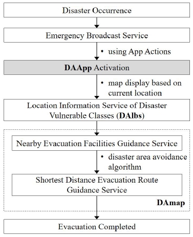
The concept of disaster response content (DAApp; disaster action application) proposed in this paper is shown in Fig. 1. If the disaster vulnerable classes receives an emergency disaster letter, the DAApp is activated by app actions feature and displays the map with location of evacuation facilities based on the current location. In addition, disaster vulnerable classes can be provided with the nearest evacuation facility that avoids the disaster area.
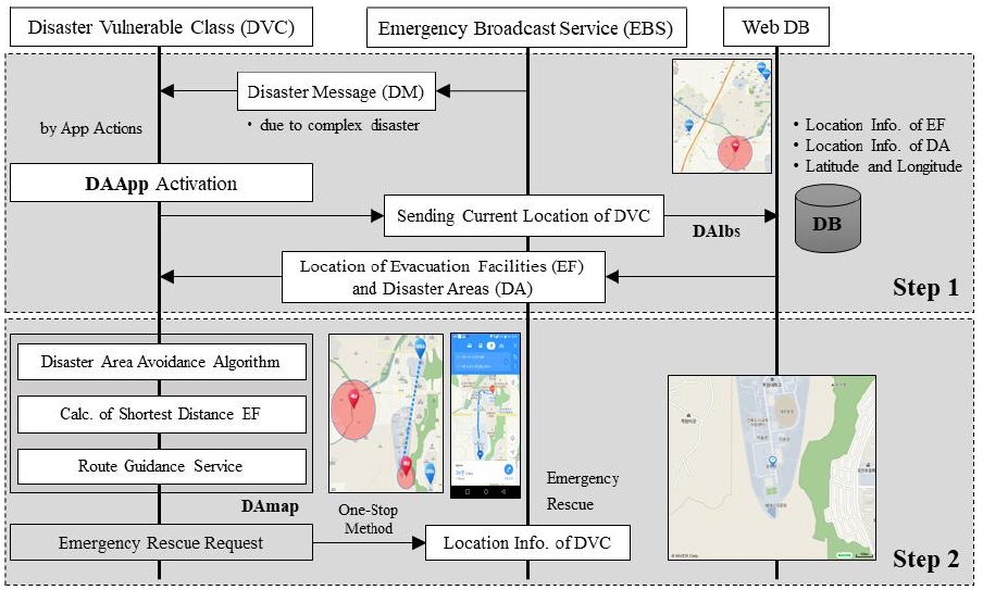
The detailed contents of the proposed contents are shown in Fig. 2, and the implementation flow of the proposed content is divided into two stages. The first stage sends and receives location information of disaster vulnerable class (DVC), evacuation facilities (EF) and disaster area (DA) between the DAApp and Web DB. In the event of a disaster, the DVC will receive emergency disaster messages. At this time, the DAApp installed in the smart device of DVC is activated, and the current location of DVC (DAlbs) is transferred to the Web DB. Then, the DVC receives the location information of the evacuation facility and the current disaster area from the Web DB.
The second stage is the actual step of DVC evacuation, the DVC is guided to the nearest evacuation facility from the current location. Here, the evacuation route is applied to the disaster area avoiding algorithm described in Section 2-3, and the DVCs that are difficult to evacuate can also request one-stop emergency rescue.
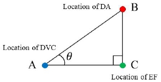
Effective disaster area avoidance should identify the distance between EF and DA based on DVC location. That is, as shown in Formula 1 and Fig. 3, whether or not the path through the DA can be determined by determining the angle corresponding to the inner product of the triangle composition. Table 2 shows the code for calculating the angle θ in Fig. 3.
| (1) |
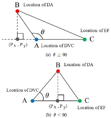
In Fig. 3, if the internal angle θ of and is less than 90 degrees, it will pass through the disaster area. The analysis of the case where the angle θ is 90 degrees or more and the case where the angle is less than 90 degrees is shown in Fig. 5. The intersection point can be calculated by drawing a line at a right angle the DA on the line . Given the straight line a1x+b1y+c1 = 0 and a2x+b2y+c2 = 0, the intersection point (Px, Py) in Fig. 4 can be obtained from Formula 2. Therefore, if the angle ϴ is less than 90 degrees, it means that the evacuation path passes through DA.
| (2) |
Ⅲ. Experiment and Discussion
In this Section, a virtual scenario is set up to test the performance of the implemented DAApp, and the implementation details are described step by step.
3-1 Virtual Disaster Situation based on Scenario
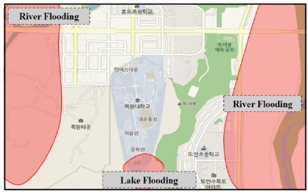
The virtual disaster situation setting is as follows. If a flood disaster occurs as shown in Fig. 5, the disaster response manager sends emergency evacuation message to the DVC.
· Disaster type : heavy rain
· Disaster occurrence date and time : 2018.11.22., 13:15
· Disaster location : rivers and lakes flooding near “OOO”
· Disaster message : [Disaster caused by heavy rain] Please evacuate urgently.
3-2 Disaster Message Reception and App Activation
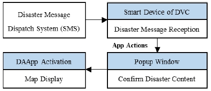
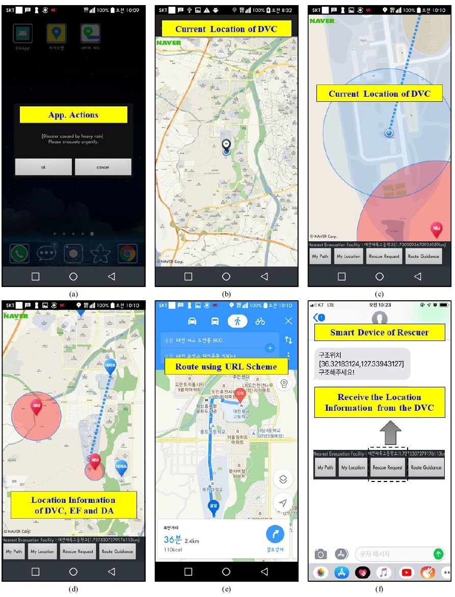
When the DVC receive disaster message, the DAApp is automatically activated by the app actions feature described in Section 2-1. The DAApp activation process using app actions is shown in Fig. 6, and the implementation result in the DAApp is shown in Fig. 7(a).
3-3 Transfer Current Location of DVC to Web DB
When the procedure in Section 3-2 is completed, the DVC transmits the current location and time to Web DB, and receives location information of EF and DA. The table structure of the Web dB is shown in Table 3, and the DVC can check the surrounding EF and DA based on the current position
3-4 Evacuation Route Guidance
The DVC can confirm the nearest EF with the DA avoidance algorithm described in Section 2-3 as shown in Fig. 7(c), and the route guidance is shown in Fig. 7(d) and Fig. 7(e).
3-5 Emergency Rescue Request
The DVC can request emergency rescue in case of inconvenience or difficulty in evacuation, and the DVC transmits the current location information to rescuer as shown in Fig. 7(f).
Ⅳ. Conclusion
In this paper, we propose and implement disaster response contents that enable disaster vulnerable classes to evacuate safely when a disaster occurs. The proposed content is focused on response time in disaster management process of prevention, preparation, response and recovery, and it is service technology targeting disaster vulnerable classes who are not ordinary people.
In particular, the implemented killer application has a great advantage that the disaster vulnerable classes can identify the evacuation facility and the disaster area around the current location, and guide the route to evacuate immediately. As a result of the implementation, it was confirmed that it is effective for the emergency evacuation of vulnerable disaster classes. The proposed content is expected to be highly scalable to various natural and social disasters such as water disaster, earthquake, fire, collapse of multi-cluster facilities.
Acknowledgments
This research was funded by the strategy research (20180543-001) of the Korea Institute of Civil engineering and building Technology (KICT).
References
-
J. Y. Gang, H. J. Jang, and H. J. Oh, “Linguistic Features Extraction for Analysis of Great Natural Disasters Damage State”, The Journal of Korean Institute of Information Technology, 15(9), p11-21, Sep.), (2017.
[https://doi.org/10.14801/jkiit.2017.15.9.11]

- H. J. Kang, J. M. Choi, and J. M. You, “A Study on the Smart Disaster Management System”, in Proceedings of the 2012 KIIT Summer Conference, p39-44, May), (2012.
- S. S. Chai, S. M. Shin, and D. J. Suh, “A Study on the Development of Korean Inventory for the Multi-Hazard Risk Assessment - Based on Earthquake Damage Analysis”, The Journal of Journal of Digital Contents Society, 18(6), p1127-1134, Oct.), (2017.
-
Y. J. Hur, and M. K. Rhee, “Development and Validation of Indirect Trauma Scale of Social Disaster”, The Korean Journal of Culture and Social Issues, 23(3), p381-407, Aug.), (2018.
[https://doi.org/10.20406/kjcs.2017.08.23.3.381]

- J. Y. Kim, S. C. Jeong, G. E. Lee, J. Y. Cho, D. W. Kim, and S. H. Park, “Visualization System for Natural Disaster Data”, The Journal of the Korea Computer Graphics Society, 24(3), p21-31, July), (2018.
- H. S. Noh, S, and H. J. Kim, “AI Technology-based Disaster Response Model for Disaster Vulnerable Classes”, in Proceedings of the 2018 International Conference on Digital Content: Smart Media, Art & Culture Technology, p61-62, Oct.), (2018.
- Android Developers, App Actions [Internet], Available: https://developer.android.com/guide/actions/.
- Naver Developers, URL Scheme [Internet], Available: https://developers.naver.com/docs/utils/mobileapp/.
- Naver Developers, Map for Android [Internet], Available: https://developers.naver.com/docs/map/android/.
- Kakao Developers, Platform API for Map [Internet], Available: https://developers.kakao.com/features/kakao.
- T Developers, T Map API [Internet], Available: http://tmapapi.sktelecom.com/.
- Google Maps Platform, Google Map [Internet], Available: https://cloud.google.com/maps-platform/maps/?hl=ko.
저자소개

2011: Department of Civil Engineering, Graduate School of Hankyong National University (M.S Degree)
2010: Department of Civil Engineering, Graduate School of Inha University (Ph.D Degree)
2007~2008: Research Center for I/S Network of Korea Infrastructure Safety Corporation
2015~now: Senior Researcher, Department of Land, Water and Environment Research, KICT
※ Research Interests: water disaster, radar image processing, deep learning, data mining , loT

2009: Researcher, Korea Environmental Institute
2012: Department of Civil, Environmental and Architectural Engineering, Graduate School of Korea University (M.S Degree)
2015~now: Researcher, Department of Land, Water and Environment Research, KICT
※ Research Interests: rain radar, vehicle radar, electromagnetic wave precipitation gauge, ecological stream restoration.

2008: Department of IT Engineering, Graduate School of Mokwon University (M.S Degree)
2018: Department of IT Engineering, Graduate School of Mokwon University (Ph.D Degree)
2004~2010: Director in Mediawork Co., Ltd.
2010~2014: CEO in DigitalC Co., Ltd.
2014~now: Director in Mediawork Co., Ltd.
※ Research Interests: computer vision, pattern recognition, object oriented programming, game programming.

2005: Department of IT Engineering, Graduate School of Mokwon University (M.S Degree)
2010: Department of IT Engineering, Graduate School of Mokwon University (Ph.D Degree)
2008~2009: Researcher in Prevention of Disaster with Information Technology RIC.
2010~2012: Senior Researcher in Inconex Co., Ltd.
2012~now: Assistant Professor in Div. of Convergence Computer & Media, Mokwon University.
2014~now: Chairman of Life Safety Division in Daejeon City Association, Safety Culture Campaign.
2015~now: Subchairman in Daejeon City Association, Volunteer of Community Safety Monitor.
※ Research Interests: computer vision, pattern recognition, H.26x, aviation application technology, disaster prevention application technology.
